Spring ![]() Summer
Summer ![]() Fall
Fall ![]() Winter
Winter ![]()
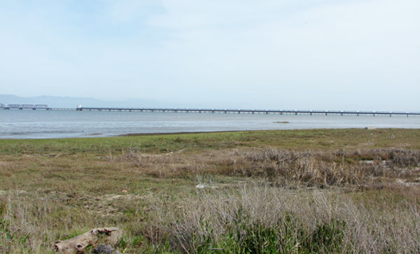
Ravenswood OSP, south side of Dumbarton Bridge, looking southeast to the old railroad bridge, March 2009 (Jennifer Rycenga)
The Dumbarton bridge is the southernmost and shortest of the bridges that span the San Francisco Bay. The area on the Alameda County side of the bridge is justly famous among birders, with the splendid Coyote Hills Regional Park to the north and the headquarters of the Don Edwards San Francisco Bay National Wildlife Refuge to the south. The San Mateo county portion of this avian rich bay coast is less famous, and has been subject to more damaging industrial uses and urban abuses than its eastern counterpart. The west anchorage and San Mateo coastal areas near the Dumbarton Bridge are now under the jurisdiction of the Midpeninsula Region Open Space District (MROSD) and the Don Edwards San Francisco Bay National Wildlife Refuge. This area is considered part of Ravenswood Open Space Preserve, but this section is not contiguous with the southern portion of Ravenswood, which has a separate entry in this online guide. Due to issues of personal safety and traffic noise, this area is underbirded, but holds great promise for high species counts, impressive numbers of birds, and unexpected rarities.
Birding at the Dumbarton Bridge has been made easier by way of a short frontage road on both sides of the highway, SR84, that leads to the bridge. The frontage roads on the north and south sides of the bridge meet at the eastern edge, where the road loops under the beginning of the bridge's rise. The frontage roads are clearly marked with brown highway signs that read "Ravenswood S F Bay National Wildlife Refuge." Just be sure that you are in the right hand lane as you approach, and that you are signaling clearly to the folks behind you!
South side of bridge: On the south side of the bridge there are grassy marshlands and some areas that are part of a major salt marsh restoration project. It is hoped that this area will improve significantly in its environmental quality; as that happens, this site guide will be updated to reflect the changes in its avian life. There is a half-mile trail that heads south from here, along a levee above an open waterway. Depending on water levels, you may find waterfowl and shorebirds here; Savannah and Song Sparrows and Common Yellowthroat use the grassy areas. Looking south toward the old railroad bridge, there are often extensive mudflats on the bay shore, but the distances are daunting, even with a scope. Snowy Plovers have been found on this side of the bridge, but rarely.
North side of the bridge: You'll likely have better luck on the north side of the bridge anchorage. The mudflats are closer here, and there are extensive areas of open water, bay, and marsh. Gulls, shorebirds, and waterfowl are to be expected in season, sometimes in huge numbers. One of the authors has seen over eighty-five Long-billed Curlews at one time; impressive rafts of Greater Scaup (usually with a few Lessers mixed in) as well as Canvasbacks are visible on the bay in winter. Other ducks include Buffleheads, Common Goldeneye and Eared Grebes, all in the winter. Among the more unusual county birds locals search for here are Black Skimmer, Ruddy Turnstone, Wilson's and Red-necked Phalaropes (migration), and the endangered Snowy Plover. This is also good habitat for rails. Black Rail are possible, though you may well despair of hearing their subtle 'ki-ki-do' above the noise of the bridge. American White Pelicans sometime drift over in winter. In summer, Cliff and Barn Swallows nest under the bridge.
The levee along the bay front (here on the north side of the bridge) is posted as no trespassing, and the breached pond is posted as private property. However, the levee on the west side of the pond is accessible and not posted in any way; however, you should not walk out here during hunting season, as indicated below. You can walk northwest along this levee to the bay, where you will be at Point Ravenswood. This hike is over a mile in length, with a grab box of birding possibilities on a range between feast and famine. Shortly after you start this walk, there is a levee on your left, running parallel to the frontage road. In the pond to the right of this levee, American Avocets and Black-necked Stilts nest. During the winter, thousands of peeps are here - primarily Least and Western Sandpipers with some Semipalmated Plovers and Dunlins. Back at the pavement, if you proceed west along the north frontage road, you come to a stop sign before the left-hand turn for re-entering the highway. If you park near here, you can walk past the stop sign and come to another open expanse of water that sometimes holds gulls and ducks. From here, you can see Sun Microsystems headquarters. Drive towards the Sun campus, and look for the coastal access parking lot just east of the main parking lot. From here you can walk a short trail along the marshy slough east of the buildings. This area has a thick concentration of Ring-necked Pheasants, an otherwise rare bird in the county. The paved trail leads to a grove of Monterey Pines and deciduous trees, which attract passerines because of the scarcity of trees in this general area. Rare geese, such as Cackling, Greater White-fronted, and Ross's, should be searched for among the Canada Goose flocks. Snowy Plover have been spotted in this area. Personal safety is less of an issue here, as Sun's own security monitor this location (and sometimes mistakenly lock the gate!). Northeast of Sun's campus, you are looking at Bedwell Bayfront Park (separate listing in this guide).
Canada Goose, Mallard, American Wigeon, Surf Scoter, Black Scoter, Greater Scaup, Lesser Scaup, Canvasback, Bufflehead, Northern Pintail, Northern Shoveler, Common Goldeneye, Barrow's Goldeneye, Ruddy Duck, Ring-necked Pheasant, Eared Grebe, Horned Grebe, Western Grebe, Clark's Grebe, American White Pelican, Brown Pelican, Double-crested Cormorant, Great Egret, Snowy Egret, Great Blue Heron, Black-crowned Night-heron, Turkey Vulture, Red-tailed Hawk, Northern Harrier, Peregrine Falcon, Ridgway's Rail, American Coot, Snowy Plover, Semipalmated Plover, Black-bellied Plover, Killdeer, American Avocet, Black-necked Stilt, Black Oystercatcher (very unusual at this location), Western Sandpiper, Least Sandpiper, Ruddy Turnstone, Marbled Godwit, Whimbrel, Long-billed Curlew, Long-billed Dowitcher, Short-billed Dowitcher, Willet, Greater Yellowlegs, Lesser Yellowlegs, Wilson's Phalarope, Red-necked Phalarope, Red Phalarope (2022, rare here), Western Gull, Glaucous-winged Gull, Ring-billed Gull, California Gull, Short-billed Gull, Bonaparte's Gull, Caspian Tern, Forster's Tern, Black Skimmer, Rock Pigeon, Black Phoebe, Say's Phoebe, Cliff Swallow, Barn Swallow, Marsh Wren, Bewick's Wren, European Starling, Northern Mockingbird, American Pipit (uncommon here), Common Yellowthroat, Savannah Sparrow, Song Sparrow, Brewer's Blackbird, Red-winged Blackbird
In this guide, "rarities" are defined as those species given an County Abundance Code of 4, 5, or 6.
Cackling Goose, Greater White-fronted Goose, Ross's Goose, Barrow's Goldeneye, Long-tailed Duck (2011), American White Pelican (uncommon but expected here), Black Rail, Red Phalarope (2022), Pacific Golden-Plover (2014), Semipalmated Sandpiper (2011, 2012, 2013, 2015 [spring appearance!], 2016, 2022), Baird's Sandpiper (2011, 2015, 2016, 2017, 2018, 2019, 2020, 2021, 2022, 2023), Pectoral Sandpiper (2014, 2022), Ruff (2023), Red Knot (2013, 2015, 2019), Jaeger sp., Least Tern (2017), Royal Tern (2023), Short-eared Owl (2012), Prairie Falcon (2019)
The area described is accessed just on the San Mateo side of the Dumbarton Bridge, off of SR 84. The signs are well-marked, but be sure that you are in the right hand lane. Especially when you are traveling east on SR84: if you miss the turnoff, you are headed for Alameda County and a $4 turnaround! The sign marked "Ravenswood S F Bay National Wildlife Refuge" is on SR84, soon after you pass University Avenue; it is the last exit in San Mateo County. The exit places you on the frontage road, on the south side of the bridge. When you are done birding the area, you can either choose to remain in San Mateo county, by heading west back on SR84, at the end of the frontage road on the north side of the bridge, or you can retrace your steps and head east on the bridge to Alameda County by exiting out the south side.
Red Markers: Parking Area or Trail Head
Hover mouse pointer over marker, or click marker, for identification.
There is no fee to use this area.
There is no official curfew here. Personally, I would not feel safe here after dark, and as mentioned above, hearing a Black Rail calling over the highway noise seems unlikely. Being here at dusk, in the winter, to search for a Short-eared Owl, might yield a sighting.
Traffic noise makes this site an unpleasant auditory experience. It is hard to hear even a Song Sparrow over the din. Personal safety is an issue, especially for a lone birder. The park signs warn of ticks and rattlesnakes, but compared to the personal safety issues, those risks are statistically insignificant. Anyone who attacked you, or vandalized your car, can jump on the highway and be gone in a flash. Because the area is flat and open, it would be obvious to a potential crook if you were .5 mile from your parked car. By contrast, the highway underpass is hidden and has some shadowy places. Both of the authors agree that this is a vulnerable spot to be alone.
Also important to note is that this area is legal for duck hunting in season. The levees that are part of the Don Edwards San Francisco Bay National Wildlife Refuge are the designated duck hunting location for the San Mateo county side of the refuge. These levees are closed to birders on weekends and Wednesdays during duck hunting season. Notices about those times can be determined on the websites for SFBNWR listed below, and should be posted at the levee gates on site, too.
There is a port-a-potty on the north side; it was clean at last check (March 2009)
There is no ranger station at Ravenswood, and because of the multiple jurisdictions for the area reviewed here, there is no truly central number to contact. The Midpeninsula Region Open Space District can be contacted at 650-691-1200; for emergencies, call for a MROSD ranger, on duty 24 hours/day, at 650-968-4411. For information on duck hunting, or other activities of the Don Edwards San Francisco Bay National Wildlife Refuge, call 510-792-0222. California Highway Patrol (CHP) uses these frontage roads often (they make a nice invisible hideaway to catch speeders coming off the bridge), so if you have a genuine emergency, help is not far away.
There are three eBird hotspots in this vicinity: one each for north of the bridge, south of the bridge, and the San Francisco Bay Trail around Facebook.
San Francisco Bay Trail-- Facebook perimeter public access trail covers the area around One Hacker Way; it holds 131 species in 37 of 48 time quadrants.
Don Edwards NWR--Ravenswood Salt Ponds R1/R2 covers the two ponds northeast of the Dumbarton Bridge, "R1" and "R2." This hotspot has data in all time quadrants representing 135 species.
Don Edwards NWR--Ravenswood Salt Pond SF2 refers to the pond on the southwest side of the Dumbarton Bridge anchorage. It, too, has data in all time quadrants representing 137 species.
Let the world know what you saw here by entering your sightings in eBird
While there is no iNaturalist place corresponding to this precise location, it is included in their larger Don Edwards San Francisco Bay National Wildlife Refuge place location. The map covering the whole refuge is informative about the piecemeal, discontiguous nature of this important resource, and is recommended for folks who are trying to understand the struggle to Complete the Refuge!
As mentioned in the description, there is a major Salt Marsh Restoration Project underway in this area.
The San Francisco Bay Bird Observatory (SFBBO) is conducting a long-range study of gull movements in the Bay Area. California Gulls have been leg-banded with plastic colored bands. If you see any of these gulls, please note the leg and the color of the band; if it is possible to read the number on the band, record that also. This information can be shared directly with Carly at SFBBO (cschacter@sfbbo.org). If the birds also have a metal band, and you can read that number, too, please report that to the National Bird Banding Lab.
Dumbarton Bridge was a popular field trip destination in the early decades of Sequoia Audubon Society's history, with sixteen field trips between 1953 and 1970. With the recent habitat upgrades, one field trip was conducted to Ravenswood Pond SF2 in 2019.

Red-necked Phalarope, April 2016 (Leslie Flint)
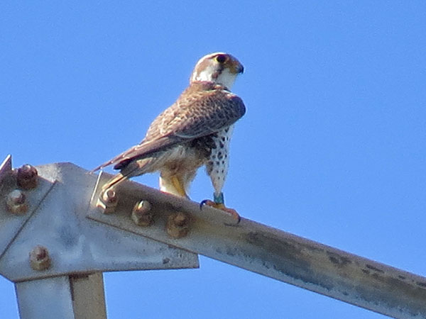
Prairie Falcon, March 2019 (Rich Ferrick)

Baird's Sandpiper, September 2018 (Kent Forward)
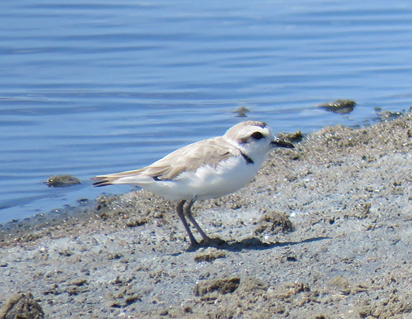
Snowy Plover, July 2018 (Chris O'Connell)
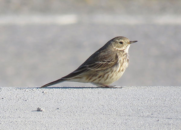
American Pipit, February 2020 (George Chrisman)
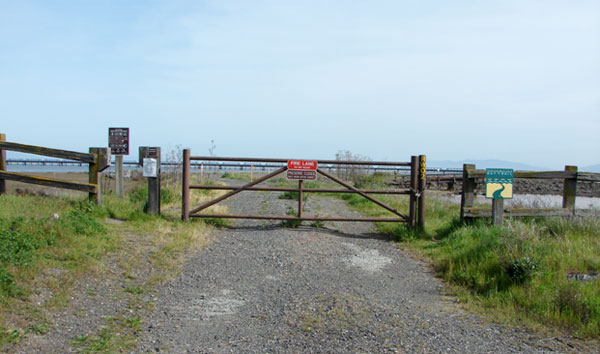
Trailhead south along levee, south side of Dumbarton Bridge, March 2009 (Jennifer Rycenga)
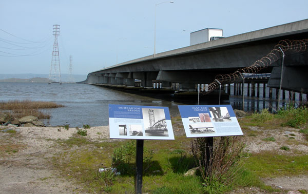
Ravenswood Storyboards, looking east at the Dumbarton Bridge, north side, March 2009 (Jennifer Rycenga)
Author: Jennifer Rycenga and George Chrisman, Uploaded: