 Summer
Fall
Winter
Spring
Summer
Fall
Winter
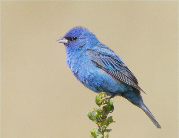
Indigo Bunting, Skyline Open Space Preserve, July 2007 (Tom Grey)
This account of Skyline Boulevard is intended to provide an introduction to this birding corridor. Almost all of the parks listed below have their own separate entries on the San Mateo County Birding Guide website.
The portion of Skyline Boulevard (Highway 35) that begins at the summit of Highway 92 (connecting San Mateo and Half Moon Bay) and winds 19 miles south to the Santa Clara line probably offers more variety in birding and nature watching than any other area in the county. Elevations between 500 and 2500 feet are easily accessible by driving one mile east or west. Habitats match this diversity in elevation and provide unexcelled birding. A drive down winding Skyline Boulevard can be enjoyed year-round, but perhaps the best time is spring and summer, when wildflowers and birds are in their glory. All the resident land birds can be found easily year-round, as well as some very special species occurring nowhere else in San Mateo County.
This is the "main street" of the Midpeninsula Regional Open Space District (MROSD), an independent governmental unit operating in San Mateo and Santa Clara Counties. Most of MROSD's preserves are located on or just off Skyline. POST, the Peninsula Open Space Trust, is a private non-profit organization that works closely with MROSD (and others), much as The Nature Conservancy works with state and federal agencies. Many of these parks are the result of the joint efforts of MROSD and POST. MROSD identifies its preserves as belonging to Groups A and B. Group A preserves have parking areas, developed trails, signs and detailed trail maps. Group B preserves have little or no on-site parking or facilities. Group B preserves do now feature trails and good signage, but are less traveled (and certainly less birded) than the Group A preserves. Almost all of the MROSD preserves are included in this online guide. To best utilize this report on Skyline, you should choose which preserves and parks you wish to visit and access those individual reports.
From north to south, here is a list of the various parks and key intersections located along Skyline Boulevard. You can use this list to plan trips along the Boulevard. MROSD preserves include indications of whether the OSP is one of the (A) or (B) group preserves. These are indicated on the large map that accompanies this entry. Click on each pin to follow this sequence of parks.
Intersection of SR 35 with SR 92
Mill Creek OSP (not yet developed or open), west side
Burleigh Murray State Park, but currently no access from Skyline Boulevard
Purisima Creek Redwoods OSP (A), west side
Huddart County Park, east sideIntersection of SR 35 with Kings Mountain (east side) and Tunitas Creek Road (west side)
Skeggs Point Scenic View (6.7 miles south of SR 92, across from El Corte Madera OSP)
El Corte Madera OSP (B), west side
Wunderlich County Park, east side (more easily accessed from SR84)Intersection of SR 35 with SR84 (La Honda Road) - this intersection has supplies and food
La Honda Creek (B, by permit only), west side
Thornewood OSP (B), just south of east side, accessed from SR84Old La Honda Road (see description below for west side of this intersection)
Windy Hill OSP (A), east side
Langley Hill Road (see description under Yerba Buena Nursery)
Coal Creek OSP (B), east side
Intersection of SR 35 with Page Mill Road (east side) and Alpine Road (west side)
Russian Ridge OSP (A), west side
Skyline Ridge OSP (A), west side
Long Ridge OSP (B), west sideIntersection with SR9 near where San Mateo, Santa Clara, and Santa Cruz counties meet
Old La Honda Road intersects Skyline 5.5 miles south of Skegg's Vista Point. Drive west .9 mile on this very narrow and winding road through a mixed forest area (where Winter Wrens, Hermit Thrushes and Northern Pygmy-Owls nest) to a steep dry rocky outcropping studded with monkeyfiower, sage, Coyote Brush and Poison Oak. This highly specialized habitat was home to one of the county's most elusive nesting species: the Rufous-crowned Sparrow. First sighted in 1981, breeding was confirmed in 1992; the birds have been scarce-to-absent in the past ten years, though. Each year between 1 and 3 pairs nested in the steep slopes on either side of the road. Butterflies and wildflowers are abundant in spring. Other interesting birds in this dry, unique habitat are Anna's and Allen's Hummingbirds, Ash-throated Flycatcher, California Thrasher, Nuttall's Woodpecker, Western Meadowlark and Lazuli Bunting. Less common but likely nesters are Lark Sparrows (in oaks near grasslands), Grasshopper Sparrows (grassland), and Black-throated Gray Warblers (oaks). Be very careful birding along this road. Very few automobiles use it, but it is a favorite for motorcyclists and bicyclists. Stop only at the pullouts and stay off the roadway when birding. After birding, find a safe place to turn around (try the wider private driveways about a mile further west) and return to Skyline.
Black-throated Gray Warbler, Lazuli Bunting
In this guide, "rarities" are defined as those species given an County Abundance Code of 4, 5, or 6.
Purple Martin (2016, 2017 - these birds used an area about 1.5 miles south of the intersection with SR 92, an open area with a radio tower), Rufous-crowned Sparrow (see text above)
Skyline Road (SR35) can be accessed from the following State Routes: SR92, SR84, and SR9. Additional roads are shown on the map.
Red Markers: Parking Area or Trail Head
Hover mouse pointer over marker, or click marker, for pin identification.
Use + or - buttons to change map zoom. Click & Drag to pan.
The road is free. The only park along this stretch that requires an entry fee is the main entrance to Huddart County Park (see description in this guide).
Skyline Boulevard is heavily traveled, by people in fast cars, people on faster motorcycles, and mountain bikers. There are ample opportunities for accidents, very small shoulders, and lots of windy sections. Furthermore, the presence of perpetual parklands means the presence of perpetual wildlife, making night driving even more challenging. Please exercise extreme care when driving on this route, and do not attempt to do casual car-birding here.
All of the parks listed here, most of which are covered in more detail elsewhere in this guide, are in the heart of Mountain Lion territory. Your chances of encountering one are slim to none, but it is better to be aware than caught unawares. All of the parks also host ticks and poison oak.
There are restrooms at the parking lots of the (A) preserves and at the Yerba Buena Nursery. Restaurants and supplies can be most easily found at the intersection of SR35 and SR84, or in Woodside, about six miles east along SR84.
Accessibility information is currently not available for this location.
Author: Dan Keller and Jennifer Rycenga
Uploaded:
March 30, 2009
Last Update:
March 28, 2021 8:49am
All content ©Sequoia Audubon Society and others
No use without written permission
