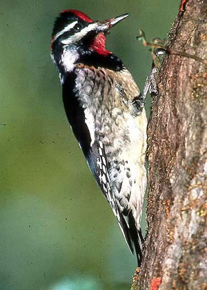
Another visitor confused by our traffic?
Red-naped Sapsucker that visited the
county in 1986. (Peter LaTourrette)
Another visitor confused by our traffic?
Red-naped Sapsucker that visited the
county in 1986. (Peter LaTourrette)
For many birders traveling to San Mateo from other parts of California, or from further afield, the intricacies of Bay Area traffic patterns, and the high likelihood that one can get stuck in a traffic jam, discourage adventurous exploration of the area. However, with a few well-placed cautions, and a few local hints, you can dodge the worst of the traffic woes and be outside with your birding companions and avian friends instead.
The county expands in width as it moves from north to south. There are four primary north-south routes in the county: from east to west
US101
I-280
SR 35 (Skyline Boulevard)
SR 1 (Pacific Coast Highway, or PCH)
There are fewer east-west routes in the county, and crossing the Santa Cruz Mountains slows most of them considerably. The three primary ones that hold highway status are
I-380 (very short)
SR92
SR84
In general, the traffic pinch points increase as one approaches San Francisco during commute hours, and at peak weekend hours. The Palo Alto area also tends to have congestion during weekdays. The patterns involving the coast will be dealt with separately.
US101
The most severe traffic problems occur along the Bayshore, on US101 to be precise. It pays to get to Coyote Point County Park early - both because that is the best time to start looking for migrants, and because US101 can become very slow along its entire San Mateo county length during commute hours. My experience has been that getting to US101 prior to 7:15, or after 9:30 am, helps reduce time lost to sitting in traffic. This is true through the length of the county. The good news, should you find yourself in a bad traffic situation, is that there are excellent birding locations off the highway at nearly every exit along US101. Among the best in this regard: Marsh Road to Bedwell Bayfront Park; Redwood Shores Parkway to the Nob Hill pond and Radio Road; Hillsdale Boulevard to the Foster City shell bar; Dore Avenue (NB) or Poplar (SB) to Coyote Point; Millbrae Avenue to the Millbrae/SFO mudflats. The unfortunate part of this, though, is that there are very few good city streets, especially east of US101, on which you can parallel the highway when the going gets tough. El Camino Real (SR82) is not a good alternative, and does not give regular access to good birding areas. If you are in the vicinity of the airport, I-380 is a very brief east-west connecting route between I-280 and US101. Its only exit is for SR82. Millbrae Avenue, which runs from I-280 to the bay itself, can be a city-street alternative for getting to SFO or to US101 or I-280.
I-280
The I-280 corridor is generally better than US101; this author uses it on her daily commute, from SR92 south through the county, and after five-plus years, can still count the number of traffic jams on the San Mateo county portion on her digits! The place where I-280 jams up is north of SR92, often just past the intersection for I-380, in the South San Francisco and Daly City areas. On weekends, there are almost no traffic jams on I-280, even in its northern reaches. [I-280 NB gives one access to the better birding areas in San Francisco (Golden Gate Park, Lake Merced, Land's End, etc.) without having to deal with downtown traffic. The San Francisco portions of the San Francisco Peninsula Birdwatching book are available at the webpage of the San Francisco Field Ornithologists .]
SR 35
SR 35 (see Skyline Boulevard Overview in this guide) can be treacherous on weekends, not because of traffic jams, but because of the mixed traffic uses: the area is crawling with mountain bicyclists, motorcyclists, and sightseers. Adding car-birding to the mix is not a good idea. Shoulders are narrow, and the potential for accidents quite high. Most of the good birding along this road - and there is plenty of it - requires you to get out and hike. That is the safer course, and more enjoyable.
SR 92
The truly monumental traffic headache for birders in San Mateo County involves reaching the coast. SR 92, in its stretch from I-280 to SR1, can often be a very slow logjam, especially on weekends and pre-eminently in October during Pumpkin Festival time. If you want to visit Half Moon Bay during October, my advice is to arrive very early in the day. But my best advice is for you to reconsider your plans, and drive instead to some other coastal location that can be reached from SR1 in Pacifica, or from the south. Half Moon Bay can be full of traffic, devoid of parking, and chock-full of people in the fall. During the Mavericks surfing contest (date flexible), the same cautions apply. During weekends the rest of the year, it is still best to get an early start and arrive at or before dawn. Once you are committed to SR92, you are stuck there (except for the always tempting possibilities offered by SR35): there is no escape from SR92 (other than Skyline Boulevard) until you have arrived in Half Moon Bay proper. You are surrounded by great habitat as you wind down into HMB, but no easy hiking access into it; when traffic is really slow, roll down the window: I've heard choruses of Swainson's Thrush, Wilson's and Orange-crowned Warblers that way!
SR 1
In general, there are few traffic problems once you reach the coast. However, the tricky pass on SR1 known as Devil's Slide, between Montara and Pacifica, is currently experiencing the construction of a tunnel. Should there be a road collapse along the existing Devil's Slide (and there have been some significant ones in the recent past), or during periods of intense construction, this stretch of road could be very slow or even out of commission.
Coming to the coast from the south, along SR1 from Santa Cruz, is usually problem-free, and one of the most beautiful drives in North America.
Various roads connect SR1 to SR35, in addition to SR 92. These are described in various sites here, but this author recommends Tunitas Creek Road as a good alternative to SR92. SR84 connects Woodside to San Gregorio, and has many opportunities for good birding. Pescadero Road, connecting to Alpine Road, is quite long and narrow, but the entire length of the road gives access to excellent parks, from agricultural lands to redwood forests.
Traffic Reports
Traffic reports are available regularly on numerous radio stations. The two all-news format AM stations, which tend to give traffic reports at ten-minute intervals, are KCBS (740 AM and 106.9 FM ) and KGO (810 AM, traffic map ). The local NPR station, KQED (88.5 FM ) gives traffic reports every half hour through their morning and afternoon news programs. Live web resources for traffic include SFGate and 511.org.
Be safe, and remember, the early birder gets to observe as the early bird gets the worm!
— Jennifer Rycenga